


septmoncel

jjjf01
User

Length
16.2 km

Max alt
1231 m

Uphill gradient
480 m
Km-Effort
23 km

Min alt
957 m

Downhill gradient
474 m
Boucle
Yes
Creation date :
2025-05-15 08:10:15.803
Updated on :
2025-06-11 18:27:30.887
6h31
Difficulty : Medium

FREE GPS app for hiking
 SityTrail
IGN / Geographical institutes
SityTrail Plus
The world is yours!
About
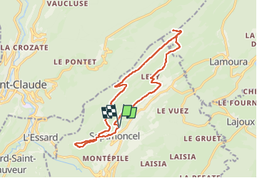
Trail Walking of 16.2 km to be discovered at Bourgogne-Franche-Comté, Jura, Septmoncel les Molunes. This trail is proposed by jjjf01.
Photos


Positioning
Country:
France
Region :
Bourgogne-Franche-Comté
Department/Province :
Jura
Municipality :
Septmoncel les Molunes
Location:
Unknown
Start:(Dec)
Start:(UTM)
724148 ; 5139622 (31T) N.
Comments